WATER OVER NICKEL UPDATE: FOLLOWING THE WATER
October 4, 2026
Band members helped put water, manoomin, health and long-term accountability into the public record. Now the DNR will decide which issues become part of the environmental study.
By Charlie Lippert, Air Quality Specialist, Department of Natural Resources Environmental Programs, Mille Lacs Band of Ojibwe
What the Band Told the NR, and What You Helped Put in the Record
The public comment period on the Tamarack Mining Project closed on September 14. For sixty days, from July 12 forward, the Minnesota Department of Natural Resources accepted comments on the two documents that will decide what the State studies before it decides anything else about this mine.
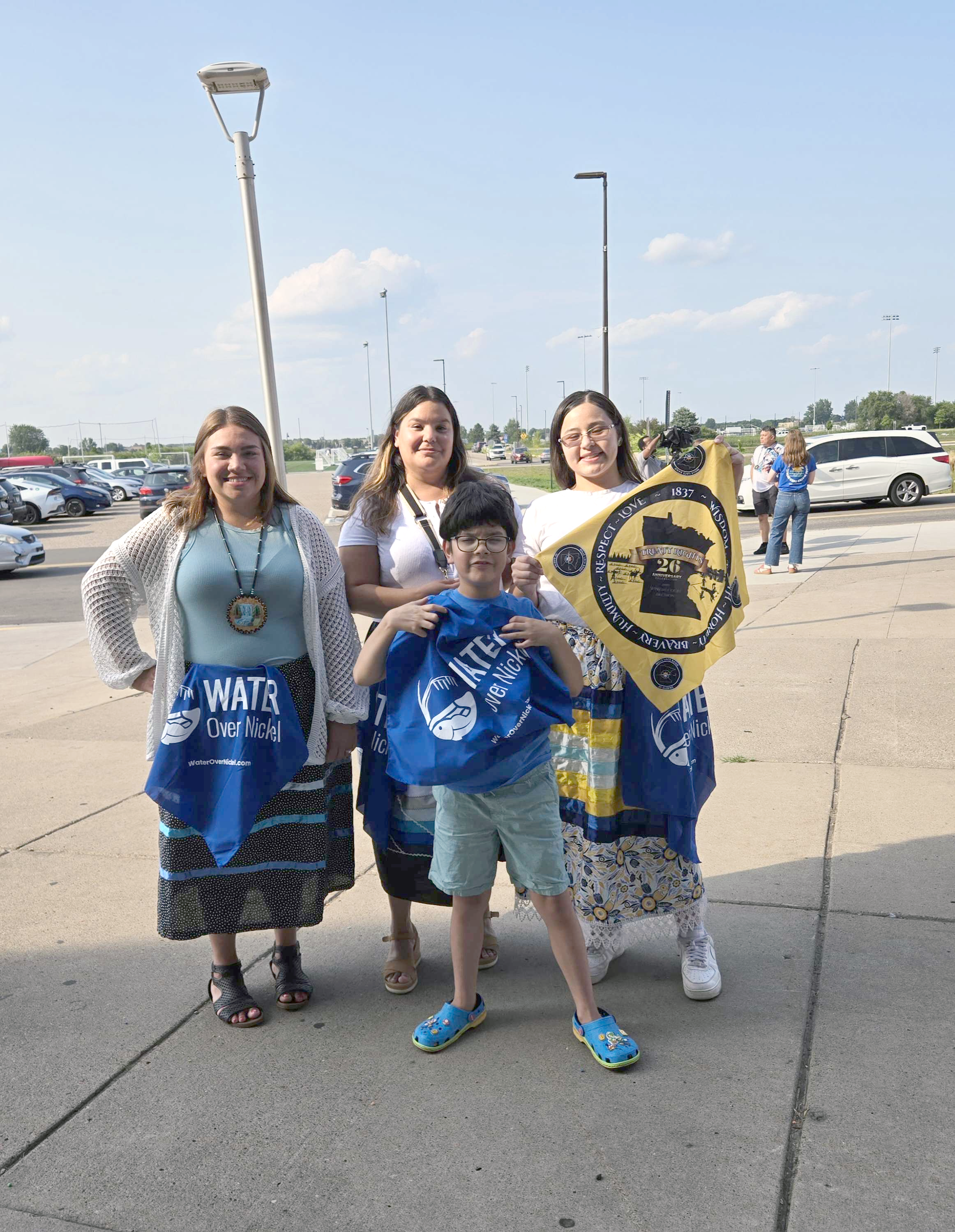
Band members showed up. You came to the open house and the public meeting at McGregor High School on August 5, and to the meeting at the National Sports Center in Blaine on August 12. You put your names on the speaker list knowing that speakers were drawn at random, that you would get three minutes, and that you would only get to speak once. You submitted written comments. You wore blue. You brought your families.
Miigwech. That participation is now part of a record the State is obligated to answer.
WHAT THE BAND FILED
On September 9, Chief Executive Virgil Wind signed and submitted the Band's comments to the DNR. The letter runs 297 pages. It contains 152 detailed technical comments organized into 26 subject categories, 62 general comments, and six appendices.
That is a large document, and the size is deliberate. Scoping is the stage of environmental review where the boundaries of the study are set. Whatever is left out now does not get studied later. A question that is not scoped in is not analyzed, is not modeled, and does not appear in the Environmental Impact Statement that decision-makers will eventually read.
The letter was reviewed by the Band's Department of Natural Resources, the Solicitor General's office, and outside counsel at Earthjustice, Lockridge Grindal Nauen PLLP, and Holland & Knight.
WHAT THE BAND ASKED FOR
The comments cover a great deal of ground, but a few threads run through all of them.
Water has to be studied as one system. The mine site sits in peat country — by the State's own accounting, roughly two-thirds of the project area is peat and muck soils. Water there moves through wetlands, shallow groundwater, ditches, and streams as a connected whole. The Band asked that the study area be drawn to follow water rather than to follow a line on a map.
Sulfate and mercury are one question, not two. Sulfate discharged into peat feeds bacteria that convert mercury already stored in the peat into methylmercury — the form that builds up in fish and reaches the people who eat them. The State's documents name sulfate in one place and mercury in another and never connect them. The Band asked that the connection be studied.
Manoomin needs a baseline before the mine, not after. Wild rice abundance swings widely from year to year for reasons that have nothing to do with a mine. Without several consecutive years of survey data collected beforehand, no one will be able to tell later whether the mine caused a change. The Band asked for a multi-year baseline designed with Tribal participation.
Accountability cannot end when mining ends. Underground workings will be flooded at closure, and that water will sit against sulfide rock permanently. If it has to be treated, it has to be treated for as long as it takes. The Band asked the State to require enforceable financial assurance that puts that cost on the company, and to say in the EIS what those long-term costs are estimated to be and who pays if the company does not.
Health has to mean health. The State's own documents propose to assess a short list of health determinants, none of which addresses cultural continuity, identity and belonging, or the health of the land itself. The Band attached the Minnesota Indian Affairs Council's 2024 resolution calling for a comprehensive and independent Health Impact Assessment for any project in Minnesota that requires an ElS, and asked that one be conducted here.
WHY THE LETTER IS WRITTEN THE WAY IT IS
Readers who look at the letter will notice something unusual about its structure. The Scoping Environmental Assessment Worksheet — the State's inventory of what is known about the site — is finished. It cannot be rewritten. The Draft Scoping Decision Document, which is the actual decision about what the ElS will study, is still open.
So every one of the Band's comments points at a specific gap in the worksheet and then directs the fix to a specific numbered section of the decision document. Each comment cites the page and line where the problem appears. The Band did not ask the State to change a document it cannot change; it asked the State to set a scope that accounts for what that document leaves out.
NOT OPPOSITION FOR ITS OWN SAKE
The letter also records what the State got right. One of the six appendices is a list of matters the Band raised in earlier review cycles that the DNR has since addressed — including a commitment that the Tribal Resources Study will be a collaborative effort of the DNR, the Tribes, and the company, rather than a company product the State reviews afterward. The Band relies on several of those improvements in the comments that follow.
The Band's position is not that the study cannot be done. It is that the study has to be designed to answer the questions that matter to the people who live downstream, and that those questions have to be written into the scope now, while the scope is still being written.
WHAT COMES NEXT
The DNR is now reading every comment it received - from the Band, from other Tribal governments, from agencies, from local residents, and from people across Minnesota. The next document, the Final Scoping Decision Document, will reflect what the agency decided to include and what it decided to leave out.
There will be more chances to be heard. The next article in this series explains where the water from the mine site actually goes, and the one after that explains what the DNR does with comments and when the public gets to weigh in again.
WHERE THE WATER GOES
To understand why the Band's comments on the Lamarack Mining Project run to 297 pages, it helps to understand where the water goes.
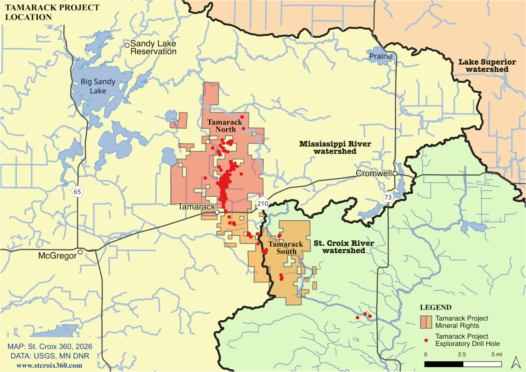
The proposed mine sits about a mile and a half north of the city of Lamarack, roughly ten miles east of McGregor and thirty miles west of Cloquet. On a map it looks like a small thing — a surface footprint of about 379 acres, with the mine itself underground. But the site sits in a landscape where nearly everything is water, and where water is connected in ways that are not obvious from the road.
A SITE MADE OF WATER
Two-thirds of the project area is peat and muck - saturated organic soil built up over thousands of years. Peat is not ground with water in it. Peat is what happens when water and plants take the place of ground. Depth to water across much of the site is measured in inches, not feet. The State's inventory counted 32 water supply wells within one mile, 24 of them serving households, and 28 of them drawing from confined aquifers beneath the surface.
Water at a site like this does not run off. It moves through - down into shallow groundwater, sideways through peat, and out along ditches and streams in every direction.
THE DIVIDE
Here is something the State's documents record but never say plainly: the surface operation sits on a watershed divide. The northern half of the property drains one way and the southern half drains the other.
Water leaving the north side enters County Ditch 13, which flows to the Lamarack River, then to the Prairie River, and then into Big Sandy Lake - Gaa-mitaawangaagamaag.
Water leaving the south side takes an entirely separate path. It enters County Ditch 23, which joins County Ditch 14 to form Minnewawa Creek. Minnewawa Creek takes in water from Mud Lake, passes the outlet of Lake Minnewawa, and flows into the Sandy River - which also reaches Big Sandy Lake.
TWO DIRECTIONS, TWO SETS OF STREAMS, ONE DESTINATION.
From Big Sandy Lake the water continues down the Sandy River into the Mississippi, and from there past every community on that river, eventually to the Gulf.
The Band's comments asked the State to study both paths. The Draft Scoping Decision Document, as written, describes only the northern one.
WHY IT MATTERS TO BAND MEMBERS
Six waters downstream of the mine are designated wild rice waters under State rules: Mud Lake, Tamarack Lake, the Tamarack River, the Sandy River, the Prairie River, and Big Sandy Lake. Manoomin is sensitive to sulfate at concentrations far below anything that would trouble a person drinking the same water.
Three of those waters - Round Lake, Tamarack Lake, and Big Sandy Lake - are already listed as impaired because the fish in them carry too much mercury. That is the existing condition, before anything is built.
And Band members live along these waters. The Round Lake Neighborhood of the Minnewawa Community is about 1.3 miles from the project area, on the receiving side of the southern drainage. The Sandy Lake, Minnewawa, and East Lake communities all sit within a few miles. Big Sandy Lake holds the Sandy Lake Cemetery and the memorial to the Sandy Lake Tragedy.
When the Band says this is not an abstract interest, that is the specific meaning.
TWO WAYS A MINE REACHES WATER
Most discussion of mining and water focuses on discharge - the treated water a mine releases from a pipe. That is real, and the Band's comments address it at length: what will be in the water, at what concentration, measured where, and against what standard.
But there is a second mechanism that gets less attention, and in peat country it may matter as much. An underground mine has to be kept dry to be worked. Pumping groundwater out of the mine lowers the water table around it — not just at the fence line, but outward, for as far as the drawdown extends. Wetlands that depend on a stable water table dry out. Peat that dries begins to oxidize. Oxidizing peat releases the phosphorus, carbon, mercury, and sulfate it has been holding for centuries.
A mine that discharged no water at all would still produce those effects. No treatment technology addresses them. The Band asked that the State study drawdown in three dimensions, through operations, closure, and afterward, and map it against wetlands, wild rice waters, and treaty territory.
BEYOND ONE WATERSHED
One more thing the map shows. The company's mineral holdings are far larger than the proposed mine. State records list 69 nonferrous mineral leases held in Aitkin and Carlton counties covering more than 29,000 acres — about 46 square miles, or roughly 78 times the size of the project now under review. Those holdings extend southeast toward the Kettle River, which flows to the St. Croix - a different major river basin entirely.
The Band asked the State to say plainly whether the study area accounts for that, and at what point future expansion would come back for a new environmental review rather than a permit amendment.
WHAT TO TAKE FROM THE MAP
Water in this landscape is one system. It moves from peat to groundwater to ditch to stream to river to lake and onward, and what enters it at Lamarack does not stay at Lamarack.
That is the reason the Band asked the State to draw the boundaries of its study by following the water, rather than by drawing a circle around the mine.
WHAT HAPPENS NEXT?
The comment period closed on September 14. A reasonable question is: now what?
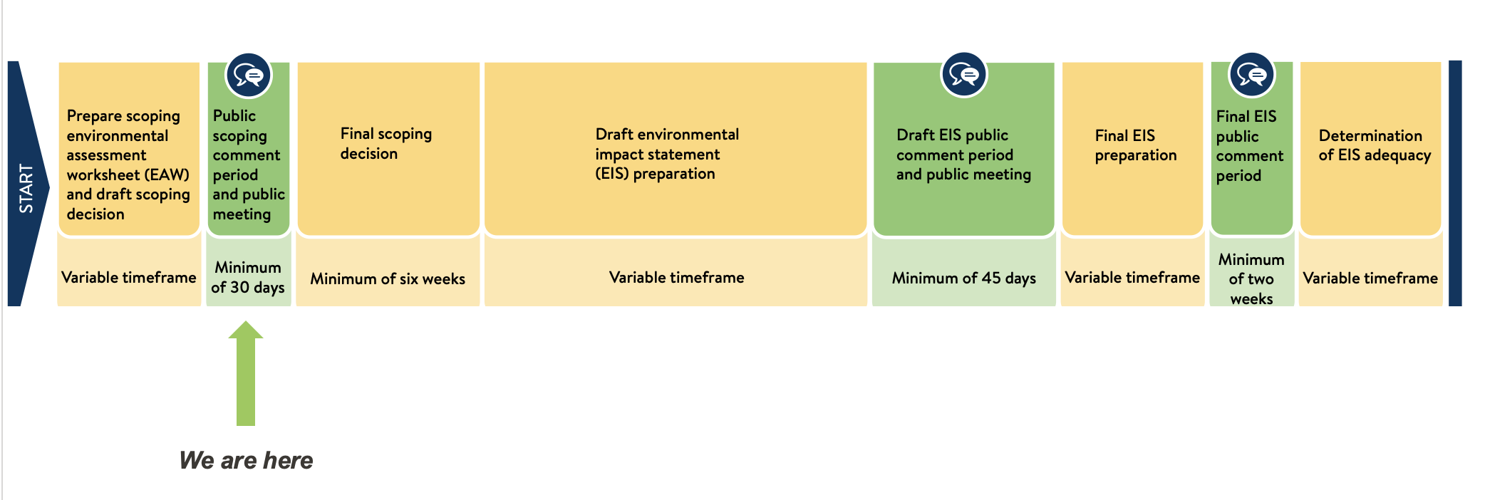
Environmental review in Minnesota moves slowly, and it moves in defined stages. Knowing the stages makes it possible to know when your voice counts again — and there are more opportunities ahead.
STAGE ONE: SCOPING (NOW)
Scoping decides what gets studied. It does not decide whether the mine is approved. The two documents open for comment this summer — the Scoping Environmental Assessment Worksheet and the Draft Scoping Decision Document — are the State's inventory of what is known and its proposal for what the Environmental Impact Statement will examine.
The DNR is now reading every comment received. Under the rules, the agency has to consider them and produce a Final Scoping Decision Document. That document is the actual decision: it lists the issues the EIS will analyze, the alternatives it will consider, and the studies that will be required.
The earliest that document could issue is roughly six weeks after the comment period closed — late October at the soonest. The schedule the DR published with the draft indicates February 2027. Either way, it is the next thing to watch for.
When it comes out, the questions worth asking are: which requested changes were adopted, which were declined, and did the agency explain why. The Band's letter specifically asked the DNR to give reasons tied to each comment rather than a general statement that a matter belongs to permitting.
STAGE TWO: EIS PREPARATION
After the scoping decision, the DR publishes an ElS Preparation Notice - currently indicated for March 2027 — and the actual work begins. This is the longest stage. Consultants and agency staff collect data, run models, and write the analysis. The company pays the State's costs for all of it, including consultants, but the DNR controls the work.
The Band participates in this stage as a Coordinating Entity, which means access to technical work and the opportunity to review it. The Band asked in its comments that this participation be written into the scoping decision so that it continues through EIS preparation rather than ending with scoping.
Public comment is not formally open during most of this stage, but it is when many of the decisions that matter get made.
STAGE THREE: THE DRAFT EIS, AND YOUR NEXT FORMAL OPPORTUNITY
The Draft ElS is currently indicated for April 2028, and it comes with a public comment period and a public meeting. This is the next time the record is formally open to everyone.
The Draft EIS is where the answers to the questions raised this summer will appear — or fail to appear. If the Band asked for a sulfate mass balance through every downstream rice water and the Draft ElS does not contain one, that absence is itself a comment worth making.
STAGE FOUR: THE FINAL EIS AND ADEQUACY
The Final EIS, indicated for January 2029, responds to comments on the draft. The DNR then makes an adequacy determination - indicated for March 2029 - deciding whether the EIS satisfies the law.
Only after an ElS is determined adequate can permits be issued. That is a separate process with its own applications, its own standards, and its own comment opportunities: a permit to mine from the DNR, water appropriation permits, and water discharge permits from the Minnesota Pollution Control Agency, among others.
WHAT THIS MEANS IN PRACTICE
Three things are worth holding onto.
First, nothing has been approved. Scoping decides the shape of the study, not the outcome of the project.
Second, the dates will move. Every one of them is described by the DNR as tentative, and schedules of this kind routinely shift by months.
Third, this is a long process, and long processes are won by people who are still paying attention at the end. The heaviest public turnout in an environmental review is almost always at scoping, when the project is new. The Draft ElS comment period two years from now will be less crowded and, in many ways, more consequential — because by then there will be an actual analysis on the table to respond to.
STAYING INFORMED
The DNR maintains a project page with all documents, fact sheets, and a sign-up for email updates.
The Band's full comment letter is available on request through the DNR, which is required to make all documents in its possession available.
Band members can also follow the Band's own updates through the Department of Natural Resources and the Water Over Nickels social media channels on Facebook, Instagram, and LinkedIn.